
Content block block-235416059-1774971658
Geodetic Control
The Geodetic Unit is responsible for maintenance of the Horizontal and Vertical control networks. Responsibilities include updating, revising and distributing the most accurate and current data available. Reports are prepared for subsidence and deformation surveys. Control maps are prepared for scour, construction, and aerial control surveys.
Research Geodetic Control in Google Earth
You can now research all Horizontal and Vertical Geodetic Control in Google Earth. Please download the Geodetic View (.kmz) file which allows you to view and download the newly formatted Control data sheets. This file will be updated periodically, so please check back to be sure that you have the latest updated version.
Please note: In order to view the Geodetic View file you need to have Google Earth installed.
Effective August 16, 2019, OCRTN data streams will no longer be available through OC Survey!
All OCRTN data streams through OC Survey will be turned off, BUT will still be available through the California Real Time Network (CRTN) hosted by the California Spatial Reference Center (CSRC).
Due to OC Survey relocating to a new building, we no longer have the ability to maintain the OCRTN infrastructure. Data streams will continue through CRTN.
What does this mean for the user?
1. 1991.35 and 2007.00 epoch data streams are no longer available
2. 2017.50 epoch data streams are available through CRTN
3. CRTN requires a NTRIP connection
4. CRTN requires and user account which is free through the CSRC.
For any questions, please contact OC Survey.
OCRTN
The Orange County Real Time Network (OCRTN) consists of 11 continuously operating GPS reference stations (CGPS) located in and around Orange County. These CGPS stations are part of the California Spatial Reference Center (CSRC) and the California Real Time Network (CRTN). OCRTN CGPS stations sample data at a 1 Hz interval (every second) and the raw data is streamed in real-time to a server located at the OC Survey office in Santa Ana. All sites contain GPS dual-frequency receivers with Geodetic choke ring antennas. This raw data along with generated RINEX files are archived for each site in 24-hour files and can be downloaded at the Scripps Orbit and Permanent Array Center. For specific epoch interval requests, please contact OC Survey.
At the same time, RTCM type 18, 19, 3, 22 messages are generated from each CGPS station and can be used for RTK surveying and are available to anyone at no cost. Users can access this data via the Internet using TCP/IP by using a wireless data modem. These data streams can be accessed from two different locations, the OC Survey office and the CSRC office. IP addresses and port assignments can be found by downloading the Procedures for Using OCRTN document shown below.
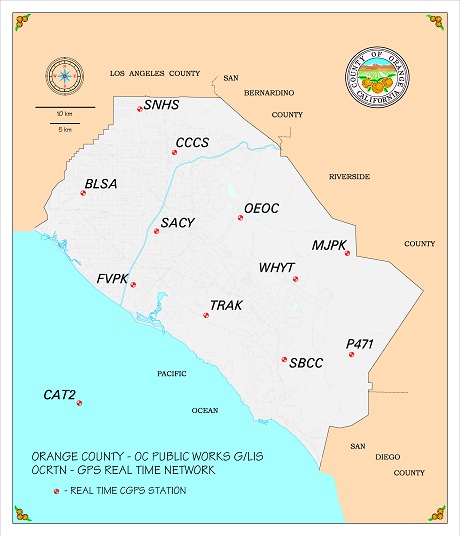 View an image of the Orange County Real Time Network
 View the California Real Time Network
OCRTN Related Downloadable Documents
Santa Ana River Calibration Base Line
The Santa Ana River Calibration Base Line was established in 1972 and is maintained by the Orange County Surveyor. It is located on the east bank of the Santa Ana River between Lincoln Avenue and Ball Road, in the city of Orange. It was designed for calibration of EDM equipment and is available to the private and public companies and agencies without charge.
In cooperation with the National Geodetic Survey (NGS), the SAR calibration base line is now part of the NGS EDMI Calibration Base Lines. The base line was re-measured in June 2006 by the OC Survey Geodetic Unit after being trained by the NGS in using their equipment and procedures.
Click here to download the "Santa Ana River Calibration Base Line" form.
Geodetic Related Downloadable Documents
- Orange County Tide Planes and Tidal Datum Relationships
- U.S. Tidal Datum Relationships and Marine Boundaries
Control Networks Horizontal
The current horizontal control datum is the CCS83, zone VI, 1991.35, 2007.00 and 2017.5 epoch adjustment. This network consists of approximately 2700 stations located on a ½ mile grid throughout the developed areas within the county. The majority of these stations have recorded cadastral references and all of them along with OCRTN, can be used to comply with the Ordinance 3809 Basis of Bearings requirement.
Vertical: The two current vertical control datum's are the NAVD 88, OCS 1995 adjustment and the NGVD 29, OCS 1995 adjustment. This network consists of approximately 1,700 benchmarks with a ½ mile spacing along the level lines throughout the county. Additional benchmarks will be added in the future as areas become further developed.
To research Geodetic Control, go to Land Records or download the Google Earth KMZ file found at the top of this webpage.
Datum and Epoch
Horizontal: Horizontal Control Points may have different coordinate values due to the datum and / or epoch date used. To avoid confusion, always state the datum and epoch as references when using GPS control points coordinate values.
Vertical: Benchmarks may have more than one height due to the datum, adjustments, and year leveled. To avoid confusion, always state the datum, adjustment, and year leveled as references when using benchmark elevation values.